AVISO Y DESCRIPCIÓN DE LA CONDENA DEL ÁREA DE MARISCOS
NÚMERO 016-057, INDIAN CREEK
VIGENTE A PARTIR DEL 15 DE FEBRERO DE 2026
De conformidad con el Título 28.2, Capítulo 8, §§ 28.2-803 a 28.2-808, § 32.1-20, y § 2.2-4002, B.16 del Código de Virginia.
1. El “Aviso y descripción de la condena del área de mariscos número 016-057, Indian Creek”, vigente desde el 15 de diciembre de 2024, queda cancelado a partir del 15 de febrero de 2026.
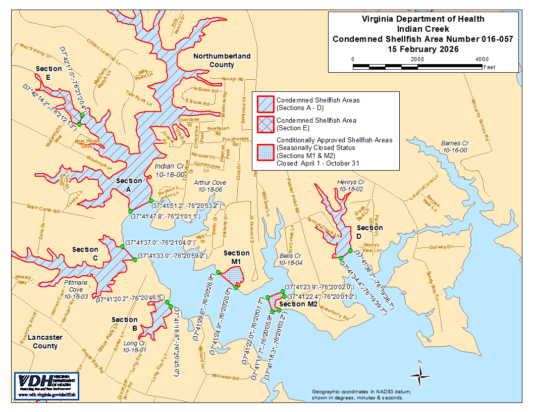
2. El Área de Mariscos Condenada Número 016-057, mostrada como las Secciones A a la E, queda establecida por la presente, efectiva el 15 de febrero de 2026. En cuanto a las Secciones A a la D, será ilegal que cualquier persona, firma o corporación extraiga mariscos de estas áreas para cualquier propósito, excepto mediante permiso otorgado por la Marine Resources Commission, según lo dispuesto en el § 28.2-810 del Código de Virginia. En cuanto a la Sección E, será ilegal que cualquier persona, firma o corporación extraiga mariscos de esta área, para cualquier propósito. Los límites de estas áreas se muestran en el mapa titulado “Indian Creek, Condemned Shellfish Area Number 016-057, 15 February 2026” (Área de Mariscos Condenada de Indian Creek, Número -, de febrero de ), el cual es parte de este aviso.
3. El Área de mariscos aprobada condicionalmente (estado de cierre estacional) número 016-057, que se muestra como las secciones M1 y M2, se establece por la presente con efecto a partir del 15 de febrero de 2026, y permanecerá en vigor anualmente a partir de entonces durante el período que comienza el primer día de abril hasta el último día de octubre, hasta que sea rescindida. Será ilegal que cualquier persona, firma o corporación extraiga mariscos de estas áreas mientras se encuentren en estado cerrado, excepto mediante permiso otorgado por la Marine Resources Commission, según lo dispuesto en el § 28.2-810 del Código de Virginia. Los límites de estas áreas se muestran en el mapa titulado “Indian Creek, Condemned Shellfish Area Number 016-057, 15 February 2026” (Área de Mariscos Condenada Número - de Indian Creek, de febrero de ), el cual es parte de este aviso.
4. El Área de Mariscos Aprobada Condicionalmente (estado cerrado) Número 016-057, mostrada como Secciones M3 y M4, se establece por la presente con efecto a partir del 15 de febrero de 2026, y permanecerá vigente hasta que sea rescindida. Será ilegal que cualquier persona, firma o corporación extraiga mariscos de estas áreas mientras se encuentren en estado cerrado, excepto mediante permiso otorgado por la Marine Resources Commission, según lo dispuesto en el § 28.2-810 del Código de Virginia. Los límites de estas áreas se muestran en el mapa titulado “Indian Creek, Condemned Shellfish Area Number 016-057, 15 February 2026” (Área de Mariscos Condenada Número - de Indian Creek, de febrero de ), el cual es parte de este aviso.
5. El Departamento de Salud recibirá, considerará y responderá a las peticiones de cualquier persona interesada en cualquier momento con respecto a la reconsideración o revisión de esta orden.
LÍMITES DEL ÁREA EXPROPIADA NÚMERO 016-057
A. El área condenada incluirá aquella porción de Indian Creek tierra adentro de una línea trazada entre la coordenada de mapa de latitud/longitud (37°41'47.8",-76°21'01.1") y la coordenada de mapa (37°41'51.2",-76°20'53.2"); pero excluye el área definida como Sección E.
B. El área condenada incluirá todo Long Cove y sus afluentes aguas arriba de una línea trazada entre la coordenada de mapa de latitud/longitud (37°41'20.2",-76°20'46.5") y la coordenada de mapa (37°41'18.8",-76°20'45.0").
C. El área condenada incluirá todo Pittmans Cove y sus afluentes aguas arriba de la línea trazada entre la coordenada de mapa (37°41'37.0",-76°21'04.0") y la coordenada de mapa (37°41'33.0",-76°20'59.2").
D. El área condenada incluirá aquella porción de Henrys Creek aguas arriba de la línea trazada entre la coordenada de mapa (37°41'34.4",-76°19'39.7") y la coordenada de mapa (37°41'36.7",-76°19'36.1").
E. El área condenada incluirá aquella porción de Indian Creek y sus afluentes aguas arriba de una línea trazada entre la coordenada de mapa de latitud / longitud (37°42'17.0",-76°21'20.4") y la coordenada de mapa (37°42'14.2",-76°21'21.3").
M1. El área aprobada condicionalmente (estado de cierre estacional) incluirá aquella porción de Indian Creek tierra adentro de una línea trazada entre la coordenada de mapa de latitud / longitud (37°41'29.6",-76°20'26.9") y la coordenada de mapa (37°41'24.9",-76°20'20.0").
M2. El área aprobada condicionalmente (estado de cierre estacional) incluirá aquella porción de Bells Creek tierra adentro de una línea trazada entre las coordenadas de mapa de latitud/longitud (37°41'22.4",-76°20'01.2"), y la coordenada de mapa (37°41'23.9",-76°20'02.0"). coordenada de mapa (37°41'22.0",-76°20'07.7"), coordenada de mapa (37°41'17.7",-76°20'05.9"), y coordenada de mapa (37°41'18.3",-76°20'03.2").
M3. El área aprobada condicionalmente (estado cerrado) incluirá aquella porción de Indian Creek hacia el interior y aguas arriba de una línea trazada entre las coordenadas de latitud/longitud (37°42'02.4",-76°21'02.8"), la coordenada (37°41'59.3",-76°20'56.1") y la coordenada (37°41'52.1",-76°21'02.1"), así como hacia el interior y aguas abajo de una segunda línea trazada entre la coordenada (37°41'53.5",-76°21'08.8"), la coordenada (37°41'57.2",-76°21'13.7") y la coordenada (37°41'59.0",-76°21'11.5"); y se muestra como parte de la Sección A.
M4. El área aprobada condicionalmente (estado cerrado) incluirá aquella porción de Pittmans Cove tierra adentro de una línea trazada entre la coordenada de mapa de latitud/longitud (37°41'27.4",-76°21'23.7"), coordenada de mapa (37°41'28.5",-76°21'23.9"), coordenada de mapa (37°41'29.2",-76°21'12.9"), coordenada de mapa (37°41'24.4",-76°21'11.5") y coordenada de mapa (37°41'24.0",-76°21'13.8"); y se muestra como parte de la Sección C.